
Today's Gospel in Art - Jesus went to Galilee, leaving Nazareth
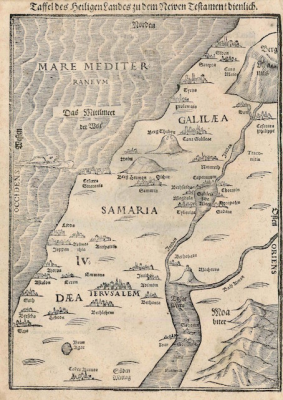
Holy Land Map by Heinrich Bünting Published in 1582, Woodcut print © Christian Art
Gospel of 7th January 2021 - Matthew 4:12-17,23-25
Hearing that John had been arrested, Jesus went back to Galilee, and leaving Nazareth he went and settled in Capernaum, a lakeside town on the borders of Zebulun and Naphtali. In this way the prophecy of Isaiah was to be fulfilled:
'Land of Zebulun! Land of Naphtali!
Way of the sea on the far side of Jordan,
Galilee of the nations!
The people that lived in darkness has seen a great light;
on those who dwell in the land and shadow of death
a light has dawned.'
From that moment Jesus began his preaching with the message, 'Repent, for the kingdom of heaven is close at hand.'
He went round the whole of Galilee teaching in their synagogues, proclaiming the Good News of the kingdom and curing all kinds of diseases and sickness among the people. His fame spread throughout Syria, and those who were suffering from diseases and painful complaints of one kind or another, the possessed, epileptics, the paralysed, were all brought to him, and he cured them. Large crowds followed him, coming from Galilee, the Decapolis, Jerusalem, Judaea and Transjordania.
Reflection on the Antique Map
Our Gospel reading today speaks of Galilee, Capernaum, Nazareth, Zebulun and Naphtali, Jordan, Syria… With all these geographical details Matthew wants to make clear that Jesus was a real person who lived in a particular place and at a particular moment in history. We read how Jesus starts his ministry, leaving Nazareth and settling in Capernaum, a busy fishing and trading centre on the Sea of Galilee.
Just as when we are travelling on holidays and using road maps to get us from A to B, the maps give us insight into the locations, local culture and points of interest, it is helpful to look at a map regularly as well when reading scripture. The more we understand the lands of the Bible, the better we will understand the Bible itself.
The map of the Holy Land that we are looking at shows most of the locations mentioned in today's reading: the Sea of Galilee at the centre left; Capernaum at the top of the lake, the river Jordan, Samaria, Jerusalem… This map was published in 1582 by Heinrich Bünting, a Protestant pastor and theologian. This page comes from a book giving an overview of biblical geography based on the travel descriptions of various notable people from the Old and New Testaments. Looking at this map and thinking of all the journeys Jesus walked makes us appreciate more the sacrifices and efforts Jesus and His Apostles made to spread the Good News…
LINKS
Today's story: https://christian.art/en/daily-gospel-reading/660
Christian Art - www.christian.art/index.php